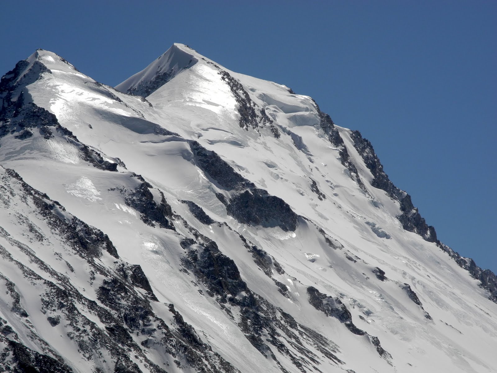
We awoke on our first morning in base camp to sunny skies and warming temperatures, a welcome change from the previous evening’s blustery and cold weather. We excitedly scrambled up the large lateral moraine separating our camp from the glacier to gain some perspective on the peaks and eyeball conditions. The view from the top of the moraine blew our minds- to the northwest, the Potanii Glacier (the largest in Mongolia) stretched on for 10 km towards the Chinese and Russian borders, guarded at it’s head by Khuiten, the country’s highest peak at 4374m (roughly 14,300 feet). To the west, the equally stunning Alexander Glacier lay before us, the massifs of Snow Church and Chinggis rising dramatically from the glacier’s flanks.

Khuiten (4374m)
(photo R. Minton)

The Alexander Glacier and beautiful Snow Church
(photo R. Minton)

Fine tuning our new home
(photo R. Minton)
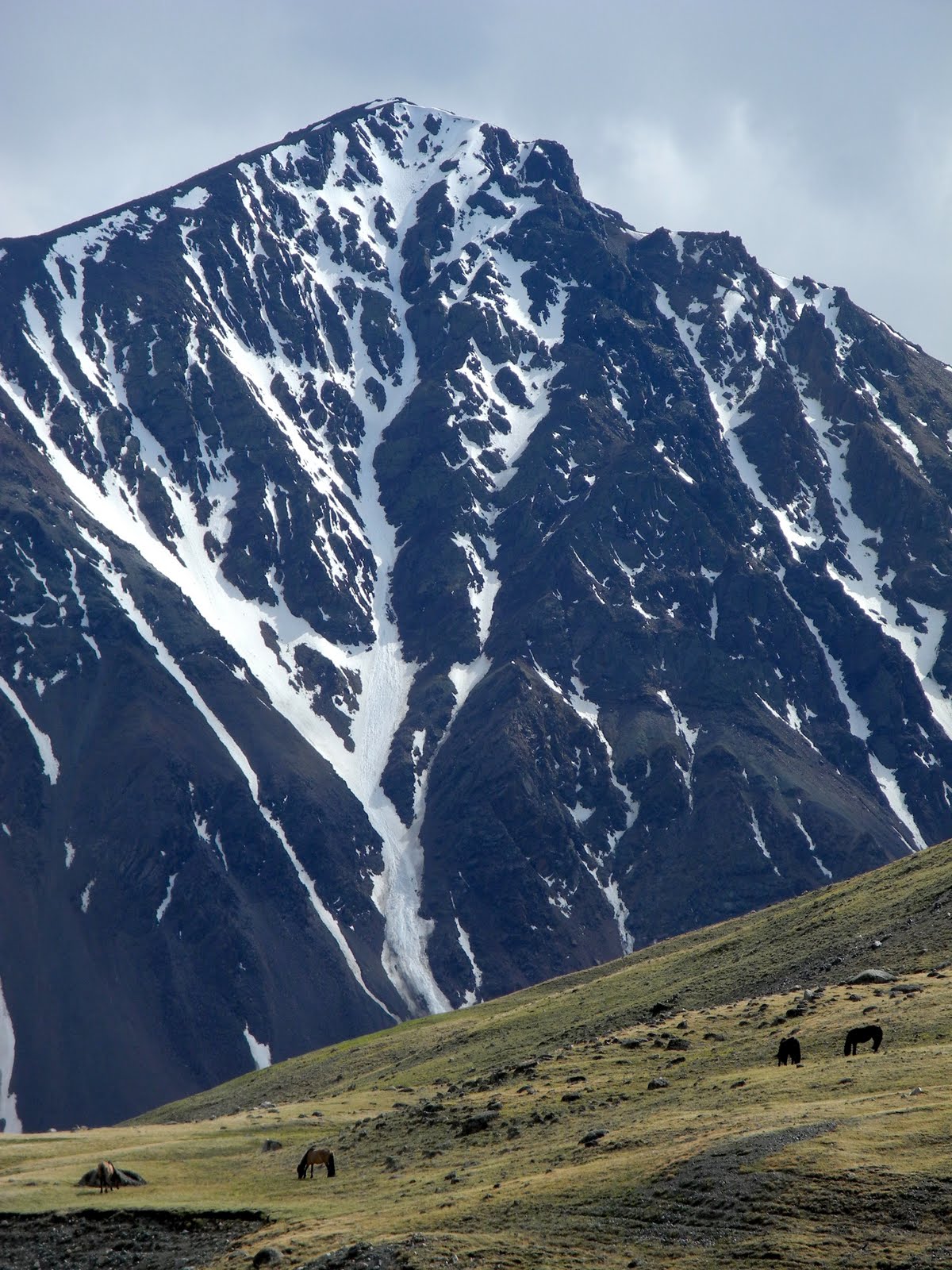
The beauty of the mountain cluster, known to Mongolians as Tavan Bogd, or Five Saints, overwhelmed us as we gazed through our spotting scope at all the peaks and potential lines we had been researching for months prior. As our scouting progressed, it became apparent that the rumored low-snow winter was indeed fact- nearly every peak we laid our eyes on was coated to some degree in large swaths of glaring blue ice. These sort of conditions are the bane of a skier’s existence, as the hard, steep ice is impossible to edge down with skis on and, moreover, incredibly dangerous to descend without a time consuming, roped belay. Some of the greatest ski mountaineers of our time have perished suddenly due to falls in such conditions- our excitement was quickly tempered by the realization that the ice would present us with yet another variable in the already complex equation of ski mountaineering.

Ice on Chinggis
(photo R. Minton)

Ice on Peak 3884
(photo CJ Carter)

Ice...everywhere
(photo R. Minton)
Our initial goal in coming to Tavan Bogd had been to link the Five Saints together in a multi-day traverse, topping out each summit and hopefully skiing each peak along the way. In order for this goal to have been even worth attempting, snowpack depth would have to be relatively deep, as we would have been skiing some of the terrain without a prior ascent to determine conditions. In their current state, there was simply no way to tell if the mountains were safe to ski without climbing the exact line of descent first. In some cases, snow was nonexistent, as rock and ice dominated a good bit of the traverse. And at that, we would come to find even the smooth, snowy sections were questionably skiable, as skiffs of snow would mask the ice, leading us into a false sense of security.

Transitioning on the way to Malchin
(photo CJ Carter)

Sunny skinning on Malchin's north shoulder
(photo CJ Carter)

Don't let the snow fool you...icy steps up high on Malchin
(photo CJ Carter)
Shifting gears, we began to map out the objectives that looked to hold promise, and our first choice turned out to be a good one. Malchin Peak, at 4050m, sits squat in the middle of the Mongolian/Russian border, and it’s northern aspects looked to be holding smooth snow at a relatively moderate angle. On our second day in camp, we set out to see what we could find on its broad, aesthetic northeast shoulder. 5km of dry trail brought us to the base of the peak, where we transitioned to ski boots and skins and began ascending low angle snow to the actual shoulder. After an hour or so of skinning, we began to notice the prominent layer of water ice under a foot of snow, and transitioned to crampons for the second half of the ascent. The ice became more prominent the higher we climbed, but the existing snow appeared to be bonding relatively well to the icy surface. This presented itself as somewhat of an anomaly to us, as we figured the ice would provide a clean and unsupportable bed surface for the snow. CJ conducted a quick stability test in a small hand pit, and determined the conditions safe, so we continued up, ascending a 20-foot wide strip of snow adjacent to a large patch of alpine ice for the final push to the summit.

Nearing the top, skirting the ice
(photo R. Minton)

Snow Church beyond lesser Altai peaks
(photo R. Minton)

One foot in Russia, the other in Mongolia on Malchin's summit
(photo CJ Carter)
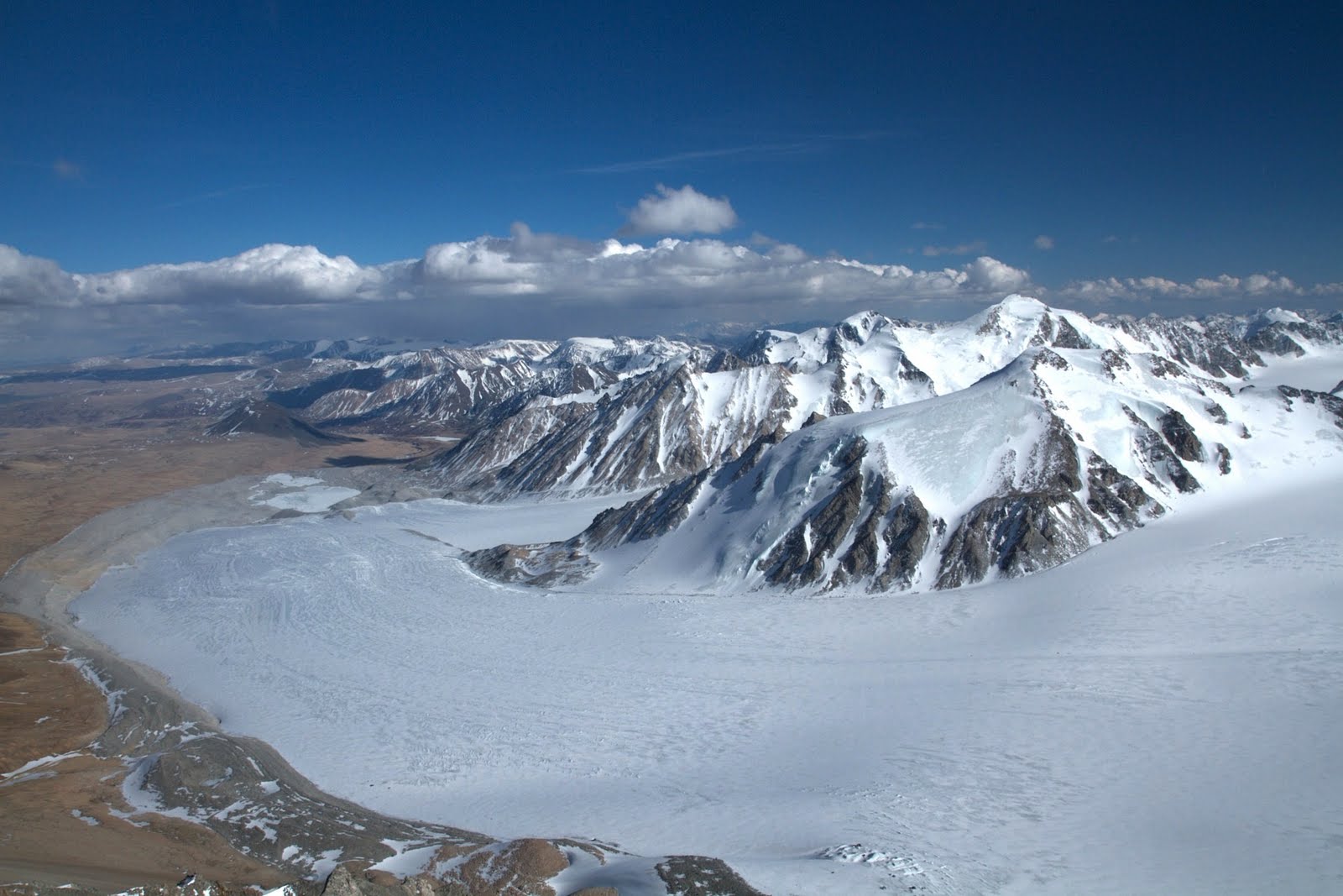
The summit ridge was wild- to the north, miles of hardened alpine ice rolled away gradually into Russia, and to our south, the rocky and relatively snow free south face of Malchin plunged over 2000 vertical feet to the edge of the Potanii Glacier. I nervously crossed the summit ridge, kicking deliberate steps onto flat but extremely icy ground, not wanting to inadvertently slip and fall thousands of feet down into Russia. We quickly reached the western edge of the summit ridge and the true summit of Malchin, where a wooden pole and blue prayer flags adorned the otherwise windswept, rocky prominence. We were granted a wonderful perspective of the Potanii Glacier from the summit, really gaining a feel for the immensity of ice sprawling beneath us.

The immense and beautiful Potanii Glacier, Mongolia
(photo CJ Carter)
A few photos later and it was time to set off on our initial ski descent in Mongolia. Luckily, a small strip of snow wound its way from the summit to the north shoulder, and we were able to click into our skis very close to the top and pick our way off the summit ridge over some rolling bulges then across a flat, firm section of snow to the rollover on the shoulder. CJ went first, pointing his skis across a section of water ice to gain some more forgiving snow. After listening to his skis skitter across the ice, I opted for a snowier but less direct line of descent, linking turns over a small roller perched on the edge of the south face. We soon were regrouped at the shoulder, and began picking our way down the upper shoulder, occasionally testing the limits of the snowy corridor, only to quickly turn and come skiing back to the safety of our bootpack after realizing that we were surrounded on all sides by ice. The skiing up high was very enjoyable- supportable, chalky, wind buffed snow allowed for smooth, fast turns. Aaron and I both commented that it reminded us of the classic wind groomed snow we often experience in Montana, working all winter long on Lone Peak. Down low, wind and warmer temps combined to make the conditions a touch more variable, breakable wind drifts threatening to grab our ski tips with every turn. We paid careful attention to our edges as we continued down over sastruggified snow, finally reaching some sunnier exposure and nice soft corn skiing out a low angle gully all the way back to the trail. A short hike back to camp had us loving our first day on skis in Mongolia, and we toasted our success with some Chinggis vodka (by far the drink of choice here in Mongolia). We hoped the conditions on Malchin were an indicator of what we would experience the rest of the trip, and decided that our next objective would be to investigate a similar aspect on Peak 3884, across the glacier from our camp.

Sastruggi up high on Malchin
(photo CJ Carter)

Riding the Russian/Mongolian border
(photo CJ Carter)
The next day brought with it rain and snow, and we spent time hydrating and storing our energy for an attempt on another peak the following day. It seemed odd to be experiencing rain at over 10,000 feet, and we hoped the freezing level wasn’t much higher- the last thing we needed was a rain crust on what little skiable snow there was. The next morning we woke at a decent hour, but determined the temps to be far to warm already to warrant crossing the glacier safely. We spent the morning prepping our glacier travel systems, and in the afternoon were paid a surprise visit by the owner of the settlement down valley and a friend of his. We invited them into our cook tent for some sweets and tea, and when the old Tuvan saw our cheap chessboard that we purchased in Olgii’s black market, he instantly challenged one of us to a match. Aaron jumped at the chance, and we all watched in awe as the Tuvan herder destroyed Aaron twice in a matter of ten minutes, skillfully shutting him down each time. Looking back, I love the fact that we could not understand each other’s language yet could find common ground on a microcosm of a medieval battleground.

It was bound to happen, really
(photo R. Minton)

Aaron takes on the Champion of Tavan Bogd
(photo R. Minton)
The next morning, we woke in the dark and after a quick breakfast of tea and oats, set out across the glacier to Peak 3884, hoping to climb its east/northeast aspect to a long, lower angle summit ridge. We were crossing the lower half of the glacier, and the crevasse hazard seemed to be rather minimal, as we cruised quickly over firm snow with minimal cracks in it. We reached the base of the peak within an hour, and transitioned to crampons for the climb. The first hundred meters or so afforded good and safe climbing conditions, with firm snow allowing us to move quickly up the lower flanks of the peak. It looked good for skiing too, and we had high hopes that the snow would remain in this condition all the way to the top. Within another hundred meters, though, we encountered deepening snow, and by the time I reached a rocky outcropping almost halfway up the face, I was punching through various crusts layered about a foot apart in the obviously still transitioning snowpack. A quick pit revealed the snow in between the crusts to be faceted and rotten, leaving little to inspire us in terms of stability. And even though it was not yet 9 AM, the upper layer was weakening from the solar energy beaming down on us from above. Above us, the terrain steepened considerably, and our gut instinct told us to pull the plug and avoid the risk of getting avalanched. Later in the day, we would see wet slide debris littering the run-out of the prospective descent.

Mid-way up Peak 3884. We would turn back shortly after this photo was taken due to heightened instability.
(photo CJ Carter)
These sorts of decisions are sometimes hard to make, but we all agreed that playing our cards conservatively in such a remote setting was the wisest thing to do. We gingerly turned down the snow we had climbed up, and skated on softening snow across the glacier. We could see the affects of the warming temperatures as we crossed, noting streams of water forming where there had been nothing at all on the ski over earlier in the morning. Back in camp by 10 AM, we cast aside our disappointments from the conditions we had just experience and decided to rest up for the remainder of the day, then rise at 2 AM the next morning and make a push for Khuiten, the highest peak of Tavan Bogd and Mongolia. From Malchin, we had been able scope the north face, and it looked like the most feasible line for a ski descent.

Clearing skies, Khuiten beckons...
(photo A. Rains)
We were out of our tents and on the trail by 3 AM the following morning, and after an hour and a half of walking parallel to the glacier, reached a small notch in the moraine where we traded trail runners for ski boots. We roped up and began skinning towards the head of the glacier, enjoying firm and fast travel conditions. By sunrise, we were nearing Khuiten, and skinned past the east face’s steep ice and many seracs as they turned brilliant shades of pink and orange. By 6:30 AM we were positioned below the northeast ridge of the peak, and our timing was great- temps were still cool and the north face, at a higher elevation, would remain cold until at least mid morning.

Pre-dawn rope management on the Potanii glacier
(photo A. Rains)

Khuiten explodes with morning light
(photo A. Rains)

Pausing to take it all in
(photo A. Rains)
We ascended into the depression below the north face and began scanning for the safest line on the peak. A beautiful gully in the center of the face looked like a nice option, but further inspection revealed wind loaded snow on its steep upper flanks and a large zigzagging bergschrund across its runout. Unsure of what these two factors would present us with, we opted for a cleaner section of the face to the looker’s right, marking the border of Mongolia and China. We navigated our way towards a col, moving over some snow bridges spanning obvious and large crevasses below the north face. Crossing the snow bridges was nerve wracking and exciting, as I was not very accustomed to this sort of travel. My senses remained alert as we continued over icy flats and a couple more snow bridges, eventually reaching the final large crevasses just below the col where we would transition to crampons. I managed the rope as CJ skinned over the snow filled abyss, and soon we were all standing on a small patch of snow (otherwise surrounded by ice) on the Mongolian/Chinese border, switching from skis to crampons for the final push up the peak. From our vantage, the face looked smooth and relatively skiable, and our hopes were high for a ski descent from the top of Tavan Bogd. We began cramponing up the face, initially encountering windblown yet stable, edgeable snow. The higher we ascended, though, the more ice we encountered. In spots, a breakable ice crust on top of sugary facets, in others a thick blue sheen of ice, unlikely to host the edges of skis. We topped out on the face within an hour, and picked our way across the L-shaped summit ridge to a knob indicated on the map to be the highpoint.

High on Khuiten's north face, near the Chinese border
(photo CJ Carter)

The wild expanse of the Chinese Altai
(photo A. Rains)

Skiing or not, we're partying; Khuiten summit
(photo CJ Carter)
Our position on the summit of Khuiten was fantastic- to the west, the Chinese Altai seemed to sprawl on forever, and to our north we could see the beautiful Belukha, the highest peak in the Altai and all of Siberia, dominating the horizon. It was 9:30 AM, the sky was blue, and the temps were cold. We took in our surroundings for a bit, then huddled around for to debate the conditions on the north face. My intuition was telling me to not even tempt the ski descent- a long, accelerating fall in this setting was completely out of the question. CJ seemed more optimistic about the descent, thinking that the ice might not present as big of an issue as we thought it would; Aaron was on the fence. Again, this instance presented us with a tough decision, as practicality clashed with desire. In the end, we decided that a descent from the summit on skis would be too risky given the conditions, and began downclimbing the face, which instantly validated our decision. Whippets were of no use in the hard ice, our technical alpine tools and crampons offering the only security as we frontpointed downward. Low on the face where the angle eased, CJ built a picket anchor and transitioned to skis, experimenting with the lower angle terrain, later reporting that it was just as bad as we had anticipated.

Walking towards China and an icy downclimb
(photo R. Minton)

Sometimes, you take skis halfway around the world to carry them downhill on your back...
(photo CJ Carter)

Testing conditions low on Khuiten's north face
(photo CJ Carter)
We regrouped down at the col, and roped up again for crossing the bergshchrund back onto the glacier. We made relatively short work of skiing roped up over the snow bridges, and soon were cruising rope-free down the low angled slush of the Potanii Glacier. We picked our way through a small icefall section, soon reaching the notch where we had transitioned onto the glacier much earlier in the day. We rested briefly then skied down the edge of the glacier to a small landing on the moraine just opposite our base camp. Tired and satisfied, we spent the rest of the day resting up and hydrating, excited to go scope a line we had been eyeing on Chinggis the next day.

Crevasse management while descending Khuiten
(photo CJ Carter)
We woke the next morning to unsettled weather, and by sunrise it was snowing heavily, transitioning to rain by mid morning. I took the opportunity to catch up on some much needed sleep, as living at or above 10,000 feet for over a week had begun to take a noticeable toll on my body. Later in the evening, the rain returned in full force, pouring down on our base camp and likely higher up in the mountains as well. We turned in hoping to wake to dry conditions, and that we did, leaving camp under azure skies by 5 AM. We began crossing the lower half of the glacier en route to Chinggis just as the morning sun painted the tips of the peaks orange. The glacier, however, seemed to be abnormally noisy for this early in the morning, and as we approached the halfway point, we discovered why. Warming temperatures and excessive precipitation had turned the center of the glacier into a veritable river, with ice-cold glacial water raging down a gigantic ice runnel. The runnel had not been there days prior when we skinned across the glacier, and further examination revealed even more waterways braiding their way down the glacier. Under my skis, a couple inches of rotten, hollow snow sat above clear, re-frozen water ice, giving the impression that we were standing on a rapidly melting lake. The writing on the wall, it was all too obvious- the glacier was rapidly becoming inhospitable for travel of any sort, and we opted out of the increasingly dangerous crossing, not wanting to even consider how risky it would be later in the day on a return trip to camp.

Early morning, en route to Chinggis and warm temps
(photo A. Rains)

Not your average youngster...
(photo CJ Carter)

Ski season in the Altai comes to an end
(photo A. Rains)
We returned to base camp by 8 AM in full sunshine and intense heat, and the fact that conditions were on their way out became more apparent to us with each passing minute. We spent one more day in camp then packed down valley to the Tuvan settlement. We woke on our first morning back at the settlement to the Tuvans breaking down their ger and rounding up their goats with plans to move up valley, where they would spend the summer. Our timing could not have been better, as we were granted the opportunity to fully immerse ourselves in their move, helping them break down the ger and load up all their belongings into a giant truck which would transport literally every bit of their lives to a different location. Seeing the true colors of a nomad family in action was fascinating- their whole world was wrapped up, packed, and moved within a matter of three hours, and on a hike later in the day into the lesser, southern peaks of Tavan Bogd we saw their new camp already established, fully prepared for a summer of goat herding in the mountains.

Still curious, Tuvan camel man and son
(photo CJ Carter)

Time to move
(photo taken from video footage, R. Minton)

Packing up, moving on
(photo taken from video footage, R. Minton)
The Furgon arrived the following afternoon, and we left the settlement, driving east out of the mountains and back into the valley of the Tsagaan Gol, where late in the evening our driver veered off the double track and delivered us to a beautiful plot of green grass right next to the river. We struck camp here, feasting on the rest of our food while taking in a beautiful sunset over the mountains. The next morning, we continued our drive back to Olgii, detouring to Sagsai to visit Khada’s family where they treated us to milk tea and a delicious lunch of dried sheep meat and rice. Khada’s older brother, an eagle hunter, proudly displayed his bird to us after lunch. Eagle hunting takes place in the winter months, where the hunters take to the plains on horseback, eagles on their arms, in search of small game (foxes and wolves) for the eagles to attack and kill. It is not necessarily a subsistence activity, but more sport, and an impressive one at that as we couldn’t help but compare it to hunting tactics commonly utilized back in the United States.

Our camp on the Tsagaan Gol, Bayan-Olgii, Mongolia
(photo R. Minton)

Capturing the beauty
(photo CJ Carter)

Mongolian hunting weapon of choice
(photo R. Minton)
We reached Olgii by early evening and checked in to a comfortable local ger camp. Hot showers and a delicious meal at the local Turkish restaurant were welcome changes to our mountain routine. The following day, CJ returned to Sagsai with our friend Bek to continue with some immersion in the Altai foothills, while Aaron and I spent the weekend here in Olgii. Tomorrow, we return to Ulaanbaatar for a couple more days of city life before boarding our return flight to the United States. For Aaron and I, our travels are quickly winding down, and we could not be happier with the course of our journey through the far reaches of Mongolia.

The expanse of the Potanii and Alexander Glaciers
(photo R. Minton)
A huge thanks goes out to Marmot, Black Diamond Equipment, and Bozeman's own Mystery Ranch Backpacks for keeping us comfortable and safe with their generous equipment provisions for the trip. In addition, the flawless behind-the-scenes logistical facilitation of Aldra, Bek, and the whole crew at Mongolia Expeditions has been valuable beyond words. Should you ever travel to Mongolia and wonder how or where to go, do yourself a favor and contact these folks. We are also forever indebted to the support and assistance received from the Hans Saari Memorial Fund and the Alex Lowe Charitable Foundation. It has been an honor to travel, climb, and ski in the memory of these outstanding individuals. Most importantly, thanks to our friends and family for their unconditional support. It has made all the difference in our wanderings through central Asia.

Central Asian wanderlust
(photo A. Rains)